There are very few places in Java where you can truly get away from the crowds. Even the island’s volcanoes have become busy places, a magnet for the country’s youth in particular, many of whom are seeking yet another opportunity to get that perfect Instagram shot. Some flock to the imperious Mount Semeru in East Java (as put on the map by the rather melodramatic 2012 Indonesian movie 5cm) while others visit popular volcanoes such as the twin Gede-Pangrango peaks near Jakarta, where overcrowding has become such a problem that the authorities have had to limit the number of hikers to prevent it resembling the chaotic Tanah Abang market during Ramadan.
But very few make it to Raung, a difficult-to-reach and isolated volcano in the island’s eastern-most regency of Banyuwangi, East Java. There are two routes to the peak: the so-called classic route from Sumberwringin in Bondowoso and the puncak sejati (true peak) route which begins in Kalibaru.
Of the two routes, the puncak sejati route has been attracting more hikers mainly because of the bragging rights associated with reaching the “true” peak even though the trek requires two nights on the mountain (rather than just the one night for the classic route) and a bit of rope climbing to boot.
We, however, would hike the seldom trekked classic route – as taken back in 1913 when this amazing shot of an erupting Mount Raung was taken.
The drive from Banyuwangi to Sumberwringin passes through some fairly wild and untouched areas and our driver was keen to point out places where he had seen leopards come down at night. It sounded a bit far-fetched and we didn’t see any. Maybe he was just making it up to impress us. You never can tell in Java.
Sumberwringin itself is an extremely quiet spot and the hotel – if you could call it that – felt more like a sprawling family villa with large spartan rooms that seemed to echo everything you said. Situated between our rooms and a couple of dimly-lit bathrooms was a large and murky square shaped pond - the perfect place to drown if you needed a slash in the early hours and were still under the influence after an evening’s heavy drinking.
The next day we got up at the crack of dawn and promptly clambered onto an old and battered open truck which would take us to the trailhead. Despite the early hour, however, this was not the time to be off guard, as extremely quick reactions were needed to dodge the low-hanging tree branches as we passed through verdant woodlands planted with coffee plants.
The truck came to a halt when we reached the trailhead but unlike any of the other volcanoes I have climbed in Indonesia, there was no rangers’ hut or even a small locket to purchase an entry ticket. Nothing at all: an indication, I guess, of just how rarely this route is taken, since when there is money to be made from tourists, there is usually someone taking it!
It’s a long walk in from the trailhead to the first post – around 10km – but fairly easy going as there is not much altitude gain at all. There are some tricky sections to navigate, however, where paths branch off from the main one - presumably created by the coffee farmers. The correct way is often indicated by either ribbons tied to trees or paint markings but you still have to be especially careful not to get lost if you don’t have a guide.
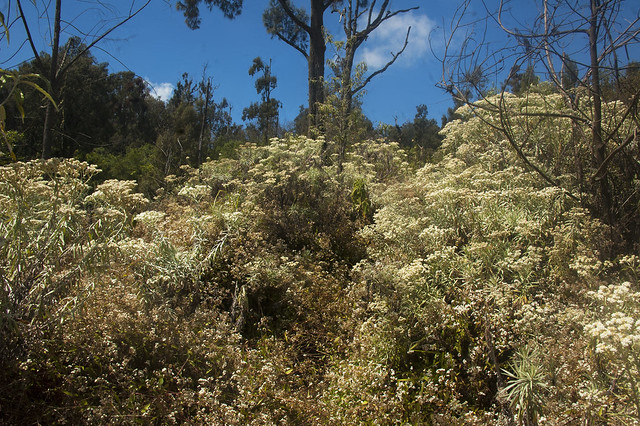
After post 1, the path steepens and a lot of the hike is then through overgrown and, at times, very high shrubs and plants which have to be brushed aside to clear the way. Arriving at the camp site in the late afternoon I realized that I had brought one less large bottle of water than I should have: I was going to get really thirsty getting down the mountain the next day!

The trek from the camp site to the summit in the early hours the following morning was extremely challenging given the steep ascent and bitterly cold temperatures, and in the final section a tad dangerous as well given the ravines on either side – one slip and well, let’s just say, that would probably have been that.
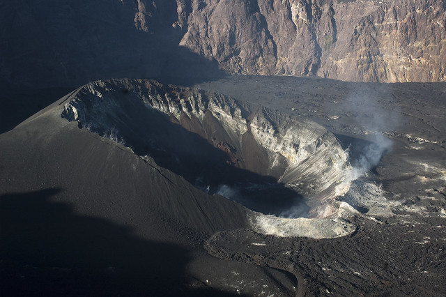
 But the effort had been worth it: the caldera was mightily impressive (measuring around 2 kilometers wide and 500 meters deep, making it the largest caldera in Java and second only in Indonesia to the immense crater of Mount Tambora in Nusa Tenggara Barat).

Reaching the summit only means the job is half done, of course, and the descent can often be as tough – or even tougher – than the ascent as: 1) you are already knackered and suffering from a lack of sleep and 2) descending is hard on the knees and if your boots aren’t tied tightly enough you can easily get badly stubbed toes – ouch! And on this particular hike it was going to get very hot on the long final section back to the trailhead– and I didn’t have much water left. It was going to be a tough day indeed!
And so it proved to be. When we finally reached the trailhead in the late afternoon, I felt like I was literally melting under the blazingly hot mid-afternoon sun. Never again I promised to myself. But vows are made to be broken. Which volcano is next?


Comments
Post a Comment